Seismograms for this Event
Event Info
| Region | Off East Coast Of Honshu, Japan |
| Time | 2005-11-14 16:38:51 -0500 |
| Magnitude | 6.7 MB, 6.8 MS, 7.0 MW, 6.9 MW, |
| Depth | 11.0 km |
| Latitude | 38.107 |
| Longitude | 144.896 |
| Distance | 83.13 deg |
| Azimuth | 45.318 deg |
| Back Azimuth | 314.113 deg |
Station Info
| Id | CBKS |
| Name | Cedar Bluff, Kansas, USA |
| Latitude | 38.814 |
| Longitude | -99.7374 |
| Begin Time | 1994-09-11 20:00:00 -0400 |
| End Time | 2999-12-31 18:59:59 -0500 |
Seismograms
| US.CBKS. .BHZ 18.670118 AD 2005.11.14 21:47:05.084 GMT |
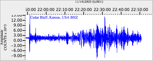
|
| US.CBKS. .BHN 2.977787 AD 2005.11.14 21:47:10.484 GMT |
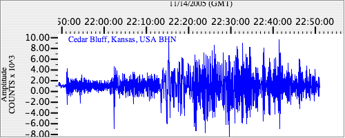
|
| US.CBKS. .BHE 3.4662209 AD 2005.11.14 21:46:56.784 GMT |
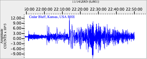
|