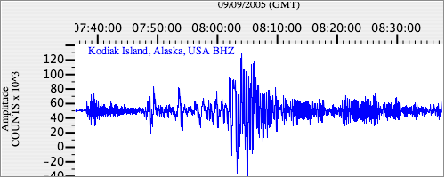
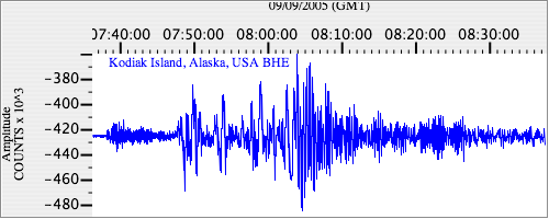
Seismograms for this Event
Event Info
| Region | New Ireland Region, P.N.G. |
| Time | 2005-09-09 03:26:43 -0400 |
| Magnitude | 6.3 MB, 7.7 MW, 7.5 MW, |
| Depth | 90.0 km |
| Latitude | -4.539 |
| Longitude | 153.474 |
| Distance | 75.644 deg |
| Azimuth | 26.553 deg |
| Back Azimuth | 236.295 deg |
Station Info
| Id | KDAK |
| Name | Kodiak Island, Alaska, USA |
| Latitude | 57.7828 |
| Longitude | -152.5835 |
| Begin Time | 1997-06-08 20:00:00 -0400 |
| End Time | 2599-12-31 18:59:59 -0500 |
Seismograms
| II.KDAK.00.BHZ 13.054673 AD 2005.09.09 07:29:29.150 GMT |
|
| II.KDAK.00.BHN 3.569814 AD 2005.09.09 07:30:49.150 GMT |

|
| II.KDAK.00.BHE 4.7857695 AD 2005.09.09 07:28:52.950 GMT |
|