Seismograms for this Event
Event Info
| Region | Off Coast Of Northern California |
| Time | 2005-06-14 22:50:53 -0400 |
| Magnitude | 6.2 MB, 7.1 MS, 7.2 MW, 7.1 MW, |
| Depth | 10.0 km |
| Latitude | 41.301 |
| Longitude | -125.97 |
| Distance | 26.815 deg |
| Azimuth | 85.435 deg |
| Back Azimuth | 287.935 deg |
Station Info
| Id | CCM |
| Name | Cathedral Cave, Missouri, USA |
| Latitude | 38.0557 |
| Longitude | -91.2446 |
| Begin Time | 1996-06-07 17:00:00 -0400 |
| End Time | 2599-12-31 18:59:59 -0500 |
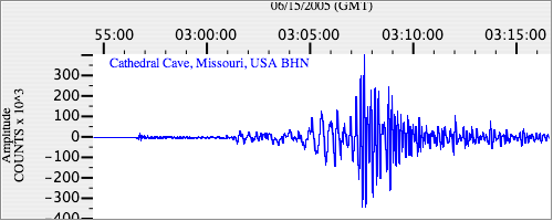
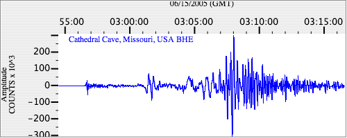
Seismograms
| IU.CCM.00.BHZ 14.920226 AD 2005.06.15 02:47:27.337 GMT |

|
| IU.CCM.00.BHN 5.3076463 AD 2005.06.15 02:47:11.537 GMT |
|
| IU.CCM.00.BHE 17.850002 AD 2005.06.15 02:50:28.837 GMT |
|