Seismograms for this Event
Event Info
| Region | Mindanao, Philippines |
| Time | 2005-02-05 07:23:15 -0500 |
| Magnitude | 7.1 MO, |
| Depth | 486.3 km |
| Latitude | 5.3634 |
| Longitude | 123.2288 |
| Distance | 33.944 deg |
| Azimuth | 138.822 deg |
| Back Azimuth | 315.776 deg |
Station Info
| Id | CTAO |
| Name | Charters Towers, Australia |
| Latitude | -20.0882 |
| Longitude | 146.2545 |
| Begin Time | 1998-10-06 17:00:00 -0400 |
| End Time | 2599-12-31 18:59:59 -0500 |
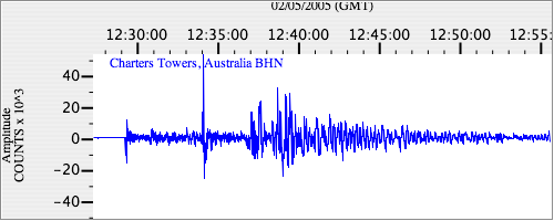
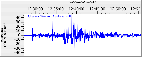
Seismograms
| IU.CTAO.00.BHZ 64.720375 AD 2005.02.05 12:23:28.661 GMT |

|
| IU.CTAO.00.BHN 34.803013 AD 2005.02.05 12:23:59.761 GMT |
|
| IU.CTAO.00.BHE 41.075832 AD 2005.02.05 12:24:58.861 GMT |
|